FishNEMO is a web interface designed to receive, store, process and access data provided by NEMO beacons. and is supplied free of charge to NEMO user through a secure login to a web based User Interface. Is is a function rich application utilising maps and layers to display vessel and environmental data.
Functions include, but are not limited to, :-
Vessel information
Vessel position
Vessel historical positions
Zone creation/administration
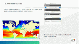
Weather and Sea information
Mapping tools – (measurements, ETA, layers, etc.)
Trajectory animation
Report creation
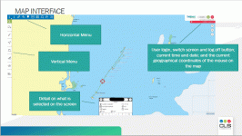
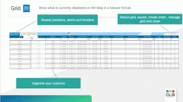
Example screen shots from the application FishNEMO